High Alpine Trails of Nevado de Toluca
- Mar 15, 2018
- 6 min read
Updated: Jan 3, 2022

Nevado de Toluca, overlooking Lake of the Sun
We are enveloped by other-worldly clouds. The hills, fields, and city below are lost to us as we make our final ascent to the volcano's towering ridge. In my seven months living in Mexico City, it's here, on Nevado de Toluca, that I've felt most at home.

Pico de Fraile and the multi-colored slopes
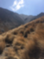
What I love most are the colors, this volcanic dust, and rubble of purple, green, brown, and red cascading down to the lake's edge. Memories of fire, kissed by snow. Dry, spiny mountain roses stick up out of the golden fields for as far as the eye can see. High above the pines, being surrounded by rocks and scree that melt down into the high alpine grasslands.

Rosas de la montaña
Silence on the alpine trail is peacefully resounding: I've gone a complete Saturday afternoon on the trails without seeing another person. Few people get off the short entrance trail that leads to the base of the mountain and lagoons, leaving the playground open for those with a sense of adventure.

Resting by Lake of the Sun
Nevado de Toluca is the fourth tallest mountain of Mexico behind Iztaccihuatl, Popocatepetl, and Pico de Orizaba, all of which are part of the 1,000km Trans-Mexican Volcanic Belt. Before its violent eruptions, the mountain was thought to be some 900 meters taller. Nevado was once called Chicnautécatl, meaning Nine Peaks or Many Peaks, which perfectly describes the crater walls. The most recent eruption happened only some 3,300 years ago. It's believed to still be active, somewhere below calm magma lies waiting. At the base of the crater are two lakes, Lake of the Moon and Lake of the Sun.

Mountain Roses and Pico de Fraile
Bringing old and new friends from the United States, France, Canada, Brazil, and Mexico to this mountain has been one of my greatest joys. With proper preparation, a good sense of direction, and adequate shoes (and water) Nevado de Toluca is the most accessible high mountain summits in Mexico. By car, it's only an hour and a half from Mexico City and lodging in the Parque de Venados and in the small town of Raíces make a morning trek all the more simple.


If you're visiting Nevado and are looking to hike, there are two routes I suggest:
Northeastern Route to Pico de Águila
The short and fun way. I first fell in love with Nevado on this trail last fall. While Pico de Águila lies below Pico de Fraile, the views from the summit and its easy access are quite stunning. If you're used to the altitude it can be summited in less than two hours. Best in warm, dry weather.

Lagoon Vista Point, from here take the trail on your right. Pico de Águila is the furthest on the right.
Follow the major road to the left from Parque de Venados. Park on the eastern slopes with the rest of the crowd and make the easy walk up to the lagoons vista point. At this crest, look for a trail on your right leading you up the rolling ridge. The first high, rocky point you can make out is your destination.
If you're early in the morning before the clouds have risen and have your luck with good weather, you should be able to make out Iztaccihuatl and Popocatepetl to the southwest as you climb.


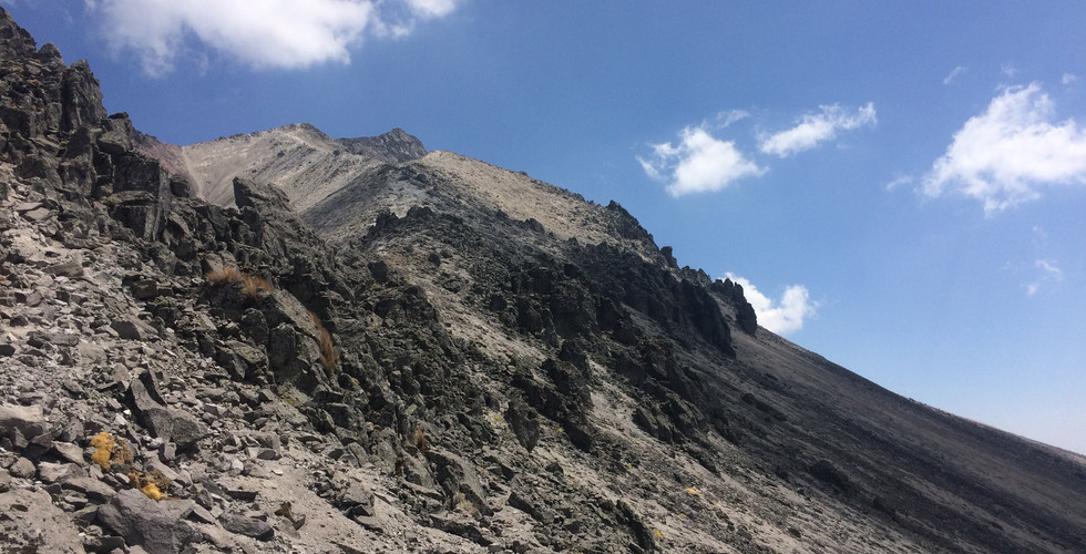
The northeastern route up Nevado de Toluca
The first part of the trail is straightforward. Keep hiking up, through the scree field, and down again. As you descend briefly and begin towards the rock cliff, get ready for the technical (read: fun) bit. The last section of the climb requires good wits, good shoes, and a good eye for trail finding.

The climb should get no more difficult than this
Stay to the right and climb on the outer northern face of the ridge. At no point should you have to climb up a rock wall to continue on the trail, though at times a hand might be necessary to pull oneself up. Turn back or find an alternative route before you find yourself without a way of turning back.

Northeastern, outer face of Nevado de Toluca
In fall and winter, you're likely to hit snow or ice. I've climbed this trail with some light snow but wouldn't do it if the path was completely covered. The boulders can get slippery; one wrong move and it's a long way down.
Though the last section can be tricky, the summit is worth it. When you reach the top you're standing at the northeastern side of Nevado at some 15,223ft. To the east is Toluca, then the Sierra de Las Cruces and Mexico City.

View of Pico de Fraile from Pico de Águila
Pro-tips: Take care if you want to continue on to Pico de Fraile from this point; I've heard tell there is a crevasse and repelling gear is advised if you hope to continue on the ridge. On the way back down, the scree field makes for a fun-filled running course.
Northwestern Route to Pico de Fraile
The scenic long way. Though I've only been here once, the trail is etched in my memory. In about three hours you climb from the main access road to the highest summit of Nevado de Toluca. It's more populated by hikers and tour guides often lead clients up this route.
To get to the trail, instead of turning left with the rest of the crowd at the Parque de Venados to go up to the main Nevado de Toluca access, keep going straight. About five minutes up this road you'll hit a bend with a cozy parking area and a trailhead to your left.

Winding between the trees
The trail weaves up between the pine trees to the open zacatonal grasslands. Look for the trail that heads most directly up towards the mountain. Listen for the birds and the wind in the pine needles. Winter is migration season and central Mexico is brimming with life.

Follow the yellow grass road
In the grasslands, you have one of the most spectacular views of Nevado de Toluca from the northwestern side. From here you hike through the mountain valley towards the right-hand scree slope.
Scree slope covered in grasses: first major elevation gain on the hike
At the top of this first slope you have the option of a short side trip for panoramic views of Nevado or to continue directly to your left towards the summit.

Quick stop before the second stretch
The trail is straightforward with a good dose of incline before you hit the crater ridge. Be ready for scree and watch for loose rocks.


Northwestern trail on Nevado de Toluca
At the ridge, you're offered similar breath-taking views of the lakes below as from Pico de Águila. Continue to your right up the switchbacks to Pico de Fraile, the official fourth highest place in Mexico at 15,354 ft.

Overlooking the Lake of the Sun and the small Lake of the Moon
Protip: Stay on the trail on the descent. The scree fields to the left of where you stand on the ridge look like a tempting shortcut but finding your way back to the correct trail once you reach the grasslands can be tricky.
Fall in Love, Be Safe
"I think you're in love with the mountain," I was told one day when watching the sun setting over Nevado. I don't deny it. Nevado de Toluca is a treasure of Mexican bio-cultural heritage that stands out for its accessibility and beauty.

Clouds shadowing the slopes of Nevado
Each time I visit I leave wondering when I can come back. I want to know each of its faces. In summer and in snow, know each of its crevasses and how to work around its tricky sections. I am challenged and encouraged to grow each time we meet. Nevado de Toluca is an amazing place to hike and to learn more about the richness of the Mexican landscape.

Thin air and strong sun
Like any mountain, Nevado de Toluca deserves respect. People have died and been seriously injured on the volcano. Know your limits, bring good gear, go with people who know the mountain, and do your research in advance. The beaten trail is your friend; off-roading is dangerous to you and to others who might have to come searching for you.
For a good guide to Mexican mountains, I recommend Guía de las Altas Montañas de México y una de Guatemala by Jorge Alberto Neyra Jáuregui.